The claim was misleading as currently exposed areas may remain exposed, expand or be submerged again in the future
Attabad Lake in Hunza is popularly referred to as the “Crown Jewel” of Gilgit-Baltistan and is one of the major tourist attractions in the region. The lake was formed when the village of Attabad in the Gojal valley had a large landslide that happened on 4 January 2010.
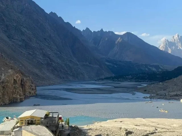
In the past few days, videos claiming to show the latest images of the lake have been making the rounds on social media, with large swaths of its once turquoise waters replaced by dry, exposed land.
Attabad Lake in Hunza, once admired as a breathtaking natural wonder, now faces concerns over its changing beauty and environmental stress.
Known for its striking blue waters and surrounded by towering mountains, it quickly became one of Pakistan’s most visited tourist… pic.twitter.com/S0CZr1QvAw
— Startup Pakistan (@PakStartup) June 4, 2026
The clip was shared by several digital media sites on X, Facebook and Instagram, as seen here, here, here and here. Some said the lake was no more, while others raised concerns about “visible decline in water levels”, linking it to environmental degradation in Pakistan’s northern areas due to “increasing tourism, unplanned activity and natural shifts”. One user also called it “the end of Attabad Lake as we know it”.
Meanwhile, people in the comments section claimed that drying up of the lake was a usual phenomenon, further fueling the debate.
WHAT WE FOUND
A keyword search conducted to confirm whether mainstream local media had reported on the drying up of the lake yielded a news report by Pakistan todaydated June 2, 2026. “What was once a deep blue, almost surreal stretch of water where tourists took boat trips and snapped postcard-perfect photos now looks dramatically different,” it said.
“Viral clips circulating on social media show wide sandy patches, shrinking water channels and areas that look more like a cold desert than a lake,” the report added.
A similar one report was carried off Pakhtun Digitala Peshawar-based independent digital news network, on June 5 titled “Attabad Lake: A beautiful masterpiece of nature now under environmental pressure”. It raised the alarm that if steps were not taken to protect the lake, it would lose its natural beauty in a few years.
Jamil Nagri, Dawn’s correspondent in GB, also confirmed that the pictures circulating on social media were accurate.
Taking a deeper dive into the science behind the lake’s water level and formation provided a Research paper from 2024 who declared that the Attabad Lake was never a typical natural lake. It was formed in 2010 after a landslide blocked the Hunza River, meaning the lake is technically a landslide-dammed reservoir – a natural body of water formed when a catastrophic landslide, rock slide or avalanche debris blocks the flow of a river.
As a result, the lake’s size and water level are affected by factors such as inflow from the Hunza River and glacier-fed tributaries, rainfall, and management of outflow through drains designed to reduce pressure on the natural dam.
The research found a gradual reduction in the lake’s surface area between 2010 and 2020. According to the authors, sediment accumulated in the lake’s upstream northern estuary as the water body developed over time, increasing the extent of exposed sediment deposits and changing the surrounding landscape.
“Due to its proximity to the source of the Hunza River, the lake experiences rapid siltation. Over time, this natural sedimentation gradually shrinks the active watershed and changes the surrounding landscape,” the paper noted.
The study further observed that changes in the lake became less pronounced after 2016, suggesting that the water mass was moving towards a more stable state.
The same was agreed by a climate expert based in GB. “The lake has not dried up; instead, it is shrinking due to high levels of silt in the lake, which is a natural phenomenon,” he told iVerify Pakistan over the phone. “This is something we have seen in most rivers across northern areas.”
Rivers in the Karakoram carry significant loads of rock, sand and fine particles eroded from surrounding mountains and glaciers.
He explained that during the summer seasons siltation of sand and soil from upstream tributaries, the lake’s main water source, made it appear as if the lake was drying up. As river water slows as it enters the lake, much of this material settles on the lake bed, gradually forming exposed mud flats and sandy stretches.
“Water still enters the lake, but it varies due to climatic factors. The huge amount of silt that accumulates in the Attabad lake makes it appear as if the lake has dried up,” the expert added.
Therefore, it cannot be determined whether the currently exposed areas will remain exposed, expand, or be submerged again in the future, as it is affected by a combination of glacier melt, river inflow, sediment deposition, and other factors.
CONCLUSION
To say that Attabad Lake has dried up is misleading.
While the viral videos accurately show exposed sediments and changes, the size and appearance of Lake Attabad is affected by natural hydrological processes, including glacial melt, river discharge and sediment deposition, making it difficult to predict future changes with certainty.
This fact check was originally published by iVerify Pakistan – a project of CEJ-IBA and UNDP.